The South Sinai mountain complex, with its granite mountains and arid landscape, consists also of narrow valleys and small oases that are of great religious and historical significance. These sites are associated with the forty year sojourn of the Children of Israel, and with the ascetic struggles of the hermits of Sinai, from the dawn of the monastic movement, to more recent years. The Holy Monastery of Sinai is located at the foot of Mount Horeb, the Mount of the Decalogue. The valley opposite the monastery is the traditional site where the Children of Israel camped. The modern village of Katrine is located here today.

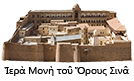
The monastery complex built around the site of the Burning Bush and the Well of Jethro developed across the centuries. The monastery catholicon is surrounded by nine chapels and a bell tower. There are a further twelve chapels within the monastery complex. Adjacent to the Tower of Saint Helen is the residence of the Archbishop and the Chapel of the Life-giving Spring. To the west are accommodations for pilgrims, and to the north are administrative offices. To the east are the old bakery and the refectory, and a range of cells. The south wing, completed in 1951, houses the library, the icon storage room, a seminar room, and other workshops and cells. 

To the west of the fortress of Justinian lie the monastery garden, the cemetery, the ossuary, and other supporting structures. From here, the path begins that leads pilgrims to the peak of Mount Sinai, as well as to the peak of Mount Saint Catherine, and the hermitage of Saints Galakteon and Episteme. The area also contains numerous chapels, gardens, and hermitages.

THE ROUTE TO THE MONASTERY

Modern visitors reach Sinai by the road that passes from Cairo through Suez. The road passes through Ras Sudr, the place where Moses turned the bitter waters into sweet. It continues through Abu Samina and the Valley of Wadi Garandil to Abu Rudeis, where the road divides. The road to the south leads to el-Tur (ancient Raitho), and on to the modern resort town of Sharm el-Sheikh. The road to the east passes by Mount Serbal and the Oasis of Pharan, and from there to Tarfa, and the Monastery of Sinai. In earlier times, it was also common for pilgrims to reach the monastery from Jerusalem, traveling south through Joppa (modern Jaffa) or Gaza, and from Eilat, down to coast of the Gulf of Aqaba, and then west to the Monastery of Sinai.

JUSTINIAN FORTRESS

The fortified walls surrounding the monastery enclosure were constructed in the 6th century at the command of the Emperor Justinian. The architect was Stephanus of Aila, which is modern day Eilat. The walls provided the monks with protection from hostile forces that would cross the area, and enshrined within the church built at the site of the Burning Bush. The height of the fortress wall varies from between ten and twenty meters, while its thickness varies from between two and three metres. The north wall of the monastery was badly damaged in 1798, and repaired by French soldiers at the time of Napoleon Bonaparte.

Read more
CATHOLICON OF THE TRANSFIGURATION

The great basilica of the Transfiguration was begun in AD 542, and completed nine years later. It incorporated the site of the original Chapel of the Burning Bush. The catholicon is a three aisled basilica that faces exactly east. It has a narthex at the western end, and a spacious apse at the east. The large four-leaved doorway at the entrance to the nave has been preserved from the 6th century. On these is carved the same verse from the Psalms that is carved over the entrance into the monastery, “This is the gate of the Lord, into which the righteous shall enter.”

Read more
HOLY BUSH

The Chapel of the Holy Bush is the most ancient shrine in the monastery, and it was around this site that the first community of Sinai anchorites gathered. The bush was mentioned by Egeria, who came to Sinai in 383-384 AC. The chapel is standing at the eastern end of the great basilica. Pilgrims enter this most holy place without shoes, in keeping with God’s command to Moses.

Read more
WELL OF MOSES

North of the catholicon there is preserved to this day the well at which Moses met the seven daughters of Jethro, as it is recorded in the scriptures (Exodus 2:15-22). The water is used by the community to this day, by means of a pump.

THE REFECTORY

When the original refectory was transformed into a mosque in the 11th century, a new refectory was built, to the east of the basilica, adjoining the ancient kitchen area in the northeast corner of the monastery. The arches of this structure were constructed from limestone blocks, and the lower reaches are covered with coats of arms and inscriptions in Latin, French, and German, the record of pilgrims who came from the West during the time of the Crusades and in the centuries subsequent to that time. Quite a number of these have been identified by modern scholars.

Read more
THE MOSQUE

The mosque is located inside the monastery, just to the west of the catholicon. The structure was modified in the 11th century. Originally it had served as the monastery refectory (from the 6th century). It is composed of three parts, with access between the three areas by means of large arched openings. In the course of recent renovations, under the plaster there were found crosses carved into the crowns of the arches.

The minaret is located opposite the monastery bell tower.

SURROUNDING AREA

The area adjoining the fortress walls includes the monastery garden, which to this day is used to grow fruits and vegetables for the sustenance of the monks. The cultivation of such an extensive garden in this arid and hostile climate is a witness to the dedication and labour of the monks. Water drawn up from the ground is held in cisterns, from where it is distributed to the trees and plants.

Read more